1784 copy of a 1568 manuscript map of Walcheren and Zuid-Beveland in Zeeland
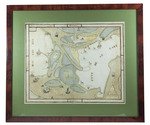
[MAP - NETHERLANDS - ZEELAND]. RUYTE, Lieven.
[Walcheren ... Zuyt Bevelant].
Tholen, Korstiaen Bestebroer, 1784. Map: 42 x 52.5 cm (frame: 61 x 71.5 cm). Manuscript map in ink and watercolour on paper (map image 37 x 47 cm) at a scale of about 1:55,000 with north at the top. Framed. Full description
€ 1,900
Tholen, Korstiaen Bestebroer, 1784. Map: 42 x 52.5 cm (frame: 61 x 71.5 cm). Manuscript map in ink and watercolour on paper (map image 37 x 47 cm) at a scale of about 1:55,000 with north at the top. Framed. Full description

