Well-executed wall map of polder land between Gouda and Utrecht
[MAP]. [VINGBOONS, Johannes, Justus and David].
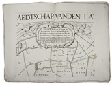
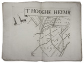
'T hooghe heymraedtschap vanden lande van Woerden.
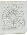
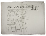
[Amsterdam, Hendrik de Leth], 1740. Wall map of the water district Woerden (South Holland) in 9 large loose untrimmed sheets (each 48 x 67 cm), with the title in a banderole across the head of three sheets, information about the 14th-century charters in a cartouche, a list of city and town officials in 1739 on a plinth, a compass rose, and a scale of Rijnland rods. Full description
€ 6,500
[Amsterdam, Hendrik de Leth], 1740. Wall map of the water district Woerden (South Holland) in 9 large loose untrimmed sheets (each 48 x 67 cm), with the title in a banderole across the head of three sheets, information about the 14th-century charters in a cartouche, a list of city and town officials in 1739 on a plinth, a compass rose, and a scale of Rijnland rods. Full description