Categories
Shopping cart (0 items € 0)
Advanced search

Low Countries

The litany of the Blessed Virgin Mary in Dutch, beautifully illustrated by the Klauber brothers

[MANUSCRIPT - RELIGION - DUTCH]. [KLAUBER, Joseph Sebastian and Johann Baptist KLAUBER (engravers)]. [Litanie van de heilige maagd Maria].
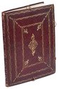
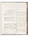
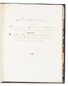
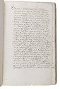
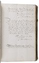
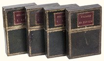
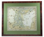
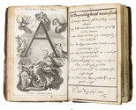
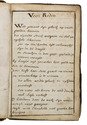
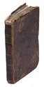
[Flanders?, early 19th century]. 8vo. With 56 tipped in numbered engraved plates, and a hand-drawn frame in brown ink on every page, in which the text is written. Contemporary gold-tooled mottled calf in a clear plastic protective sleeve, with the title lettered in gold on a black morocco spine label, engravings with red edges. [8], [1 blank], "55" [= 90] pp. Full description
€ 3,750
Order Inquire Terms of sale

Collecting the signatures of early modern Dutch "celebrities",
in a beautifully decorated late 18th-century Dutch binding

[MANUSCRIPT - SIGNATURES - THE NETHERLANDS]. Handteekeningen van I. Gecommiteerde Raden van de Staten van Holland... II. Vorsten, staatsmannen, krijgsbevelhebbers, geleerden enz. ...
[The Netherlands, early 19th century]. Large 4to. With 162 signatures on 160 vellum or paper cuttings (mostly vellum, including 2 cuttings with 2 signatures each), mostly from the 17th century, some from the 18th century and a few from the early 19th century. Further with one large printed coat of arms (of the Wassenaer family) on the verso of the title page, an engraving (ca. 9.5 x 7 cm) showing the house of Jacob Cats on the verso of leaf 34, and with 19 printed coats of arms on the versos of several leaves (16 depicting a coat of arms with the name of the family below and 3 blank shields). The title-page, headings, and captions all in a very neat late-18th-century or early 19th-century cursive script, written in Dutch using brown ink. Splendid late 18th-century (ca. 1790) gold-tooled red morocco, sewn on 4 supports with a smooth spine, bound by the so-called Second Dissertation Bindery (Leiden ca. 1780-ca. 1794; Storm van Leeuwen IIA, pp. 350-358), with 4 closing loops on the front board (1 top edge, 2 fore-edge, 1 bottom edge) connecting to 4 closing knotted buttons on the back board. Both boards show 3 gold-tooled floral frames built up from 2 different rolls with small corner pieces in between, the inner frame with 4 larger floral corner pieces and a large lozenge shaped centrepiece built up from multiple impressions of 5 different floral and animal stamps. Further with a gold-tooled spine and board edges, gilt edges, and marbled endpapers. [1], 40 ll. Full description
€ 18,000
Order Inquire Terms of sale

A treasure trove of documents about one of the most influential figures in 17th-century Utrecht, and the many people in his circle.

[MANUSCRIPT - UTRECHT - STRICK VAN LINSCHOTEN, Johan]. [Fair copies of and extracts from official documents, from 1605 to 1635, concerning Johan Strick van Linschoten (1583-1648), initially Canon and finally Secretary of the Oudmunster chapter church in Utrecht, and influential member of the States Assembly of the province of Utrecht; Prince Maurits and others].
[Utrecht], ca. 1621-ca. 1635. Folio (31 x 20 cm). Contemporary sheepskin parchment, with remnants of leather ties. Manuscript title on the spine and writing on the front board. [5 blank], "260" [= 263], [1] ll. Full description
€ 2,500
Order Inquire Terms of sale

Hand-coloured engraved map showing the rivers of Germany and the Low Countries

[MAP - GERMANY - LOW COUNTRIES]. HOMANN, Johann Baptist. Hydrographia Germaniae qua geographiae naturalis ea pars quae de aquis celebrioribus praesertim vero de fluminibus Germaniae agit...
Nuremberg, Johann Baptist Homann, [ca. 1710?]. Engraved map (48.5 x 58 cm) on a whole sheet of paper (53 x 63.5 cm), coloured in an early hand, with the title in an illustrated cartouche with Neptune and other mythological figures at lower left, an illustrated cartouche at upper left with a coat of arms, and a scale (ca. 1:2,400,000) in the margins. Full description
€ 200
Order Inquire Terms of sale

Rare wall map of the Gooi, coloured by a contemporary hand

[MAP - HET GOOI]. POST, Hendrik. Nieuwe kaart van Gooilandt word met schuldige eerbiedigheidt aan den wel. ed. gestr. Heere en Mr. Henrick Bicker schepen der stadt Amsterdam, raadt en advt. fiscaal ter Admiraliteit aldaar meestersknaap van Gooilandt, enz, enz. opgedragen door Reinier & Josua Ottens.
Amsterdam, Reinier & Josua Ottens. [ca. 1737]. 52.5 x 82 cm. Framed. Full description
€ 28,000
Order Inquire Terms of sale

Brightly handcoloured contemporary manuscript plan showing a military camp
near Korbeek/Corbais, Belgium, during the Nine Years' War

[MAP - MILITARY - LOW COUNTRIES - KORBEEK]. Plan du campement de l'armée des alliees campée a Corbay depuis le 19 Juin au 7 Juliet l'an 1696.
[Belgium?, ca. 1696]. Manuscript plan on paper (38 x 48 cm) in ink and bright watercolour. With the title in a wreath at the head, a large panel at the foot with keys identifying the camps of the various troops, and two smaller panels at the head, with keys to the villages and other locations, and a general overview map. Full description
€ 2,000
Order Inquire Terms of sale

Fine wall map coloured by a contemporary hand

[MAP - NETHERLANDS - ALBLASSERWAARD]. ]. Den Alblasserwaard en Vyf Heeren Landen, te samen groot 33110. mergen. Nieuwe caerte vertoonende den geheelen Alblasserwaert. Nieuwlycx uytgegeven door Abel de Vries landmeter tot Dordrecht 1716. Met een nette aanwijzing der dijkbreuken en hulpgaten van 't jaar 1740 en 1741. uytgegeeven door Matth. de Vries.
[Dordrecht], Matthias de Vries, [ca. 1741]. 66 x 117 cm. Wall-map on 4 sheets, originally engraved by Bastiaan Stopendaal (1637-1693), in contemporary hand colouring. Framed (93 x 143 cm). Full description
€ 9,500
Order Inquire Terms of sale

Collection of 6 maps of the Beemster polder 1644-1979

[MAP - NETHERLANDS - BEEMSTER]. FLORISZ. VAN BERCKENRODE, Balthasar and Daniel van BREEN. Beemsterlants caerte... [with a second title at the head:] Ware afbeeldinge vande bedyckte Beemster-landen... M.DC.XLIIII.
Amsterdam, 1644 [reprinted ca. 1769?].
And:
(2) [FLORISZ. VAN BERCKENRODE, Balthasar] and Daniel van BREEN. Beemsterlants caerte...
Amsterdam, 1658. Engraved map (43.5 x 58 cm).
(3) [MAP - NETHERLANDS - BEEMSTER]. Beemster landts kaarte, aenwijsende de hoogte vande ringhdyck. Als mede de diepte vande tocht & wech slooten.
[Amsterdam(?), ca. 1696].
(4-5) DORLAND, C. [2 maps of the Beemster].
Amsterdam, Tresling & Co., March 1908.
(6) [MAP - NETHERLANDS - BEEMSTER]. Waterschap de Beemster.
February 1970, updated to 1979. Large map (64 x 50 cm).
Collection of 6 maps (the first in 6 sheets). Engraved map in 6 sheets (each 56 x 44 cm). With the main title in a large cartouche at right, the statement about its production and a scale of Rijnland rods in a pedestal at the foot, a Latin verse in praise of the Beemster polder by Caspar van Baerle at lower right, a compass rose at upper right, and the arms of Beemster at the head. Bound in modern cloth (57.5 x 47 cm). Full description
€ 3,750
Order Inquire Terms of sale

Rare 18th-century wall map of the Netherlands

[MAP - NETHERLANDS]. [LE ROUGE, George-Louis]. La Hollande en 12 feuilles.
Paris, Jean Dezauche, 1790. Published on 12 sheets, numbered as 48 quarter-sheets. An engraved wall map of the Netherlands (excluding Zeeland), with the main title in a large cartouche at upper left, the Latin title at upper right. Many cities and coastlines, and a few other features, highlighted in colour. Cut, mounted on cloth and folded, in 4 contemporary gold-tooled green morocco boxes. Full description
€ 8,500
Order Inquire Terms of sale
448 books found / Show all