Categories
Shopping cart (0 items € 0)
Advanced search

Cartography & Exploration / Middle East & Islamic World

The second voyage of Paul Lucas through the Levant

LUCAS, Paul. Voyage du sieur Paul Lucas fait par ordre du Roi dans la Grèce, L'Asie Mineure, La Macedoine et L'Afrique. Contenant la description de la Natolie, de la Caramanie, & de la Macedoine.
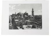
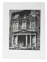
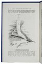
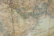
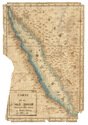
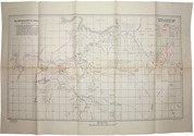
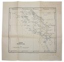
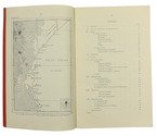
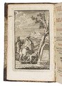
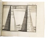
Amsterdam, aux dépens de la Compagnie, 1714. 2 parts in 1 volume. 12mo. With an engraved frontispiece and a title-page printed in red and black for each part, 9 folding engraved plates with pyramids, archeological findings, the Holy Grave, and inscriptions, 2 folding engraved maps of the Levant (engraved by B. Ruyter), and of Fioum, the Nile and surroundings in Egypt, and 8 full-page engraved plates. Contemporary half calf. [1], [1 blank], [28], 323, [1 blank]; [1], [1 blank], [8], 328 pp. Full description
€ 3,500
Order Inquire Terms of sale

Famous work on the Middle East, illustrated with very early photogravures of the Holy Land

LUYNES, Honoré d'Albert de. Voyage d'exploration à la mer Morte, à Petra et sur la rive gauche du Jourdain. ... Oeuvre posthume publiée par ses petit-fils sous la direction de M. le Comte de Vogüé.
Paris, Arthus Bertrand (on back of half-title: printed by E. Martinet (vols. 1-2) and Arnous de Rivière (vol. 3)), [1874]. 3 volumes of text and 1 atlas of plates. Imperial 4to (35.2 x 26.5 cm). With 14 numbered lithographed plates in volume 3 (4 double-page chromolithographed maps, views and geological sections; 2 further geological plates and 8 plates showing archaeological specimens), 85 plates in the atlas volume (including 65 photogravures and double-page chromolithographed maps) and numerous wood-engravings in the text. Set in roman and italic types with occasional passages in Greek and especially Arabic. Text volumes in original publisher's letterpress-printed light blue wrappers, atlas in half cloth portfolio with the original publisher's letterpress-printed paper sides, matching the text volumes; the 4 volumes preserved in 2 modern black half calf clamshell boxes. [8], 388; [6], 226; [4], VI, 326; [4] pp. Full description
€ 35,000
Order Inquire Terms of sale

Extremely rare example of the largest globe engraved by Malby (45.5 cm diameter), with lines of magnetic variation, London 1848, showing “Debai” (Dubai)

[GLOBE - TERRESTRIAL]. MALBY & CO. Malby's terrestrial globe.
[London], Malby & Co. (engraved by Chas. Malby), 1 January 1848. Diameter: 45.5 cm (18 inch), height in stand: 64.5 cm. An engraved terrestrial globe with 12 gores and 2 polar caps over a plaster-covered core, and the engraved horizon ring on the wooden stand, all coloured by a contemporary hand. In a contemporary wooden stand with 3 turned legs supporting the horizon ring, and 3 turned stretchers with a cylindrical centrepiece with a knob on the underside. Further with a contemporary brass hour circle and a slightly later iron meridian ring (and probably the axis pivots). Full description
€ 35,000
Order Inquire Terms of sale

One of the fullest descriptions of life in Sana'a and Turkish-occupied North Yemen

MANZONI, Renzo. El Yèmen. Tre anni nell'Arabia felice. Escursioni fatte dal Settembre 1877 al Marzo 1880.
Rome, Botta heirs, 1884. 8vo. With a frontispiece portrait, 21 plates (including 7 double-page sized; the last single-page plate included in pagination), 2 folding colour-printed maps of Yemen, folding plate of the game "abdùr", folding coloured plan of Sana'a, folding view of Sana'a, folding view of Aden, as well as numerous woodcut illustrations in the text. Contemporary half calf over marbled boards with blind-stamped spine and gold-stamped spine-title. Marbled endpapers. [8], VI, [2], 446 pp. Full description
€ 2,500
Order Inquire Terms of sale

"For offical use only": mapping the Mesopotamian battlefields of WWI

[MESOPOTAMIAN CAMPAIGN]. Critical study of the campaign in Mesopotamia up to April 1917. Part II - Maps.
Calcutta, Government of India Press, 1925. 25 (of 26) folding maps, sketches etc., as always lacking the "Explanation of the Method of giving Map Co-ordinates adopted in Chapters XIII and XX". Original tan cloth map-case with original printed label to cover. 25 (of 26) folding ll. Full description
€ 3,500
Order Inquire Terms of sale

The climate of the East African coast

[ARABIAN GULF]. Weather in the Indian Ocean to Latitude 30° S. and Longitude 95° E. Including the Red Sea and Persian Gulf. Volume II. Local information. Part 9 Coast of East Africa from the equator to Cape Delgado [...].
London, Meteorological Office, Air Ministry, 1940. 8vo. With map frontispiece and several illustrations and tables in the text. Original publisher's printed red wrappers. 63 pp., final blank page. Full description
€ 1,500
Order Inquire Terms of sale

Instructions for Carsten Niebuhr's expedition to Arabia

MICHAELIS, Johann David. Recueil de questions, proposées à une société de savants, qui par ordre de Sa Majesté Danoise font le voyage de l'Arabie.
Amsterdam, S.J. Baalde; Utrecht, J. van Schoonhoven & comp., 1774. 4to. Set in roman type with incidental Greek, Hebrew, Arabic, Syriac and 1 word in Coptic. Near-contemporary tanned sheepskin, gold-tooled spine. [4], XLIV, 256, [16], 38, [2 blank] pp. Full description
€ 3,500
Order Inquire Terms of sale
119 books found / Show all