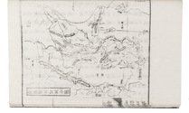
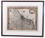
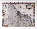
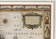
The Seventeen Provinces: a detailed map with additional views of major cities
and examples of local dress
SPEED, John [and Pieter van der KEERE?].
A new mape of ye XVII provinces of Low Germanie.
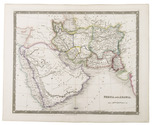
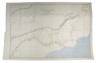
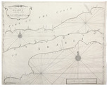
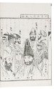
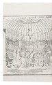
[London], George Humble, 1626. 41 x 53 cm. Engraved map with hand coloured borders, probably by Pieter van den Keere (1571-after 1646). Incorporating a fine compass-rose with 32 rhumb lines and names of the wind-directions, a coat of arms of France, a title-cartouche, a legend ("A catalogue of the cities et [!] villages in everie Province") and an indication of scale (ca. 1:1.120.000). The map is topped by 8 hand coloured miniature profiles of major cities and bordered by hand coloured figures in local costume at the left (5 male figures) and right (5 female figures). Framed. Full description
€ 4,000
[London], George Humble, 1626. 41 x 53 cm. Engraved map with hand coloured borders, probably by Pieter van den Keere (1571-after 1646). Incorporating a fine compass-rose with 32 rhumb lines and names of the wind-directions, a coat of arms of France, a title-cartouche, a legend ("A catalogue of the cities et [!] villages in everie Province") and an indication of scale (ca. 1:1.120.000). The map is topped by 8 hand coloured miniature profiles of major cities and bordered by hand coloured figures in local costume at the left (5 male figures) and right (5 female figures). Framed. Full description