Categories
Shopping cart (0 items € 0)
Advanced search

Cartography & Exploration / Geography, Topography & Views

A superb set of two lavishly illustrated descriptions of Arabia and the Middle East
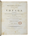
NIEBUHR, Carsten. 
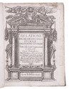
Beschryving van Arabie.
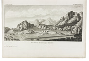
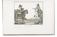
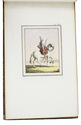
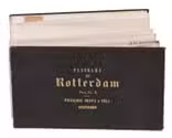
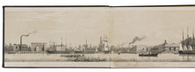
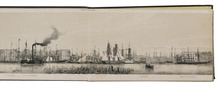
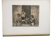
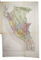
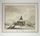
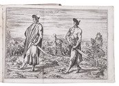
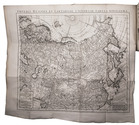
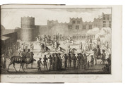
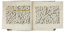
Amsterdam, Steven Jacobus Baalde; Utrecht, Johannes van Schoonhoven & comp. (colophon: printed by Johan Joseph Besseling, Utrecht), 1774. With engraved title-page and 25 engraved plates, including 7 folding showing 1 view of military exercises, 2 Kufic inscriptions (coloured by hand) and 4 maps. The unnumbered map of Yemen (plate size 58.5 x 39 cm) is coloured by hand in outline.
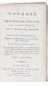
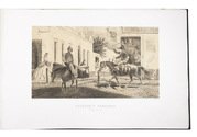
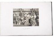
With: (2) NIEBUHR, Carsten. Reize naar Arabië en andere omliggende landen.
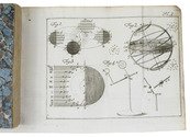
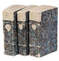
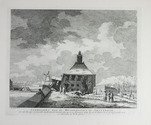
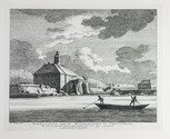
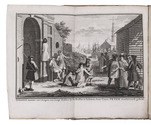
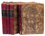
Amsterdam, Steven Jacobus Baalde; Utrecht, Johannes van Schoonhoven & comp. (colophons: printed by Johan Joseph Besseling, Utrecht), 1776-1780. With 2 engraved title-pages and 125 engraved plates (38 folding). 2 works in 3 volumes. Large 4to (28.5 x 22.5 cm). Contemporary sprinkled and polished half calf. Untrimmed. [6], XXXXI, [1], 408, [14]; [2], VIII, [6], 484, [2]; [16], 455, [1] pp. Full description
€ 10,000
Order Inquire Terms of sale

French edition of Pallas's travels through Russia

PALLAS, Peter Simon. Voyages du professeur Pallas, dans plusieurs provinces de l'empire de Russie et dans l'Asie septentrionale; Traduits de l'allemand par le C. Gauthier de la Peyronie. Nouvelle Édition, Revue et enrichie de Notes par CC. Lamarck ... et Langlès...
Paris, Maradan, an II [1794]. 8 text-volumes and 1 atlas-volume. 8vo (text) and large 4to (atlas). With 8 title-pages and 8 half-titles, 108 engraved plates and maps, of which 22 folding and 2 double-page. Uniform contemporary mottled calf, richly gold-tooled spines. [8], 422, [2]; [4], 490; [4], 492; [4], 499; 448; 455; 448; [4], VIII, 463 pp. Full description
€ 2,950
Order Inquire Terms of sale

Very rare French translation of Pallas' second expedition to South Russia,
the Black Sea and the Crimea in 1793 and 1794

PALLAS, Peter Simon. Observations faites dans un voyage entrepris dans les gouvernements méridionaux de l'Empire de Russie dans les années 1793 et 1794.
Paris, Strasbourg, Amand Koening; Leipzig, Godefroi Martini, 1799-1802. 2 text volumes and 1 atlas volume. 4to (text) and oblong folio (atlas: 24 x 40 cm). With 28 engravings in the text and 1 woodcut in each text volumes (23 hand-coloured), and 55 engraved plates and maps (43 hand-coloured) in the atlas volume. Text volumes in contemporary and uniform gold-tooled mottled calf. Atlas in matching contemporary mottled half calf. XXXII, 438; XVI, 452 pp. ; 55 ll. Full description
€ 8,500
Order Inquire Terms of sale

Spectacular views of Argentina, Brazil, Chile, Bolivia and Uruguay

PALLIERE, Jean Léon. Album Palliere. Escenas Americanas. Reduccion de cuadros, aquarelles y bosquejos.
Buenos Aires, Fusoni brothers, [1864?]. Oblong Royal folio (32.5 x 52 cm). With lithographed title-page and 52 tinted lithographed plates (image size mostly about 19 x 32 cm), lithographed by J. Pelvilain after designs by Juan Léon Palliere. Contemporary, gold-tooled green morocco. Lithographic title-page plus 52 plates. Full description
€ 39,500
Order Inquire Terms of sale

Extremely rare bound copy of a mid-19th-century panorama cityscape of the Dutch city of Rotterdam

[PANORAMA - ROTTERDAM]. Johan Conrad GREIVE jr. (illustrator). Panorama de Rotterdam.
Amsterdam, [printed by R. de Vries for] François Buffa & Sons, [1861]. Oblong (14.5 x 25 cm). The panorama is made up of 6 numbered views, which were originally published on three loose leaves of 2 views per leaf. The viewer looks northward from the river Meuse over the city from the old "sailor's house" (zeemanshuis) in the west along the Willemskade and the Haringvliet to the train station and large warehouse (rijks entrepot) in the east. Original brown blind-stamped wave-grained cloth. 6 numbered views folded making 12 pages. Full description
€ 4,950
Order Inquire Terms of sale

A great work on Peru: the first full atlas, together with an extensive statistical description

PAZ SOLDAN, Mariano Felipe. Atlas geografico del Peru.
Paris, Firmin Didot brothers, children and comp., 1865. Large folio (51.5 x 37.5 cm). With 50 engraved maps, plans and views (including 20 coloured) and 24 tinted lithographs by F. Delamare. Contemporary black half sheepskin, rebacked. [2], 82 pp. Full description
€ 5,500
Order Inquire Terms of sale

Physical and human geography for early readers

PERPONCHER SEDLNITZKY, Willem Emmery Baron de. Nieuwe aardryks-beschryving voor de Nederlandsche jeugd, tot gebruik zyner kinderen, opgesteld.
Utrecht, widow of Johannes van Schoonhoven, 1784-1786. 3 volumes. 12mo. With 4 folding engraved plates illustrating the planets, the solar system and the stellar constellations. Contemporary marbled stiff paper wrappers. XL, 532; X, 432, [1]; VI, 592, [4] pp. Full description
€ 1,750
Order Inquire Terms of sale

Pendant of a drawing in the Amsterdam city archives, together with two engravings after the drawing

[AMSTERDAM]. PHILIPS, Caspar Jacobsz. Afbeelding van de Oostzijde der Muijder Poort te Amsterdam, na dat dezelve tussen den 29 en 30 Januarij 1769 bij na 16 voeten diep in de grond gezakt was.
[Netherlands], 1772. (23 x 29 cm). Original pen drawing.
With:
(2) KEUN, Hendrik. Afbeelding van de Muyderpoort te Amsterdam, zo als die zig vertoonde, na dat dezelve tussen den 29 en 30 Jannuary 1769 by de 16 voeten in de grond gezakt was.
Amsterdam, F.W. Greebe, [1769]. (22 x 28.7 cm)
(3) KEUN, Hendrik. Afbeelding van de Muyderpoort te Amsterdam, zoo als die ingezakt synde, van buiten af te zien zig vertoond.
Amsterdam, F.W. Greebe, [1769]. (21.7 x 28.2 cm.
Two engraved views with captions below the image, both signed "H. Keun Fecit" in the plate. Full description
€ 2,500
Order Inquire Terms of sale

One of the earliest sources on the Congo and central Africa, complete with all plates and maps

PIGAFETTA, Filippo and Duarte LOPEZ. Relatione del reame di Congo et delle circonvicine contrade tratta dalli scritti & ragionamenti di Odoardo Lopez.
Rome, Bartolomeo Grassi, [1591]. 4to. With an integral engraved architectural title-page (with the coat of arms of the dedicatee Antonio Migliore, Bishop of San Marco), large folding engraved general map of Africa (64×44 cm), large folding engraved map of the Congo (43.5×51.5 cm) and 8 numbered folding engraved plates of plants, animals and inhabitants of the country, by Natalis Bonifazio. Contemporary limp sheepskin parchment. [8], 82, [1], [1 blank] pp. Full description
€ 60,000
Order Inquire Terms of sale

Rare description of Russia just after the Turkish war,
with a revised version of the first map of the entire Russian Empire

REITZ, Johann Frederik, and others. Oude en nieuwe staat van't Russische of Moskovische Keizerryk, behelzende eene uitvoerige historie van Rusland en deszelfs groot-vorsten; benevens de beschryvinge van dat uitgestrekte ryk, de zeden en godsdienst der inwoneren: zyne opkomst en voortgang in koophandel, kunsten, land- en zeemacht, oproeren, oorlogen en verdere wisselvalligheden, tot dezen tegenwoordigen tydt toe.
Utrecht, Johannes Broedelet, 1744. 4 volumes. 4to. With 4 folding maps, 3 folding plates and a folding letterpress table. Early 19th-century half red sheepskin. [2], 296; [2], 200, 200a-200d; [2], 501; [2], 830 pp. Full description
€ 4,250
Order Inquire Terms of sale
86 books found / Show all