Categories
Shopping cart (0 items € 0)
Advanced search

Cartography & Exploration / Asia

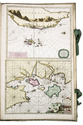
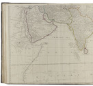
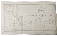
The main source of early knowledge of the Pelew or Palau Islands in Micronesia, in Dutch translation
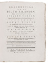
KEATE, George. Beschryving van de Pelew Eilanden ...
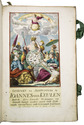
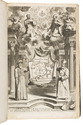
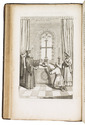
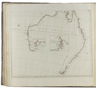
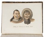
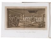
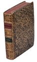
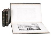
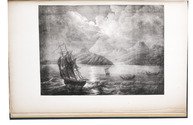
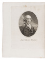
Rotterdam, Gerard Abraham Arrenberg, 1789. 4to. With 8 plates: 4 mixed technique (partly stipple-engraved) portraits, 1 large folding engraved map of the Palau Islands and western equatorial Pacific, and 3 folding engraved views. Contemporary boards. XXXII, 365, [1] pp. Full description
€ 2,500
Order Inquire Terms of sale

Spectacular 18th-century Dutch composite sea atlas with 3 detailed manuscript charts,
all charts and the engraved title page expertly coloured by a contemporary hand

[KEULEN, Gerard and Johannes van, and others]. [Composite sea atlas containing 56 detailed charts including 3 manuscript charts].
Amsterdam, [Johannes van Keulen and others, 1700-1753, engraved title page dated 1734]. Large folio (61.5 x40.5 cm). With an engraved allegorical title page by Aernout Nagtegael after Jan Luyken, and 56 detailed sea charts, the whole expertly coloured by a contemporary hand. The atlas includes 22 large folding charts, including 3 highly interesting manuscript charts, 27 double-page charts, 1 full-page chart, and 6 half-page charts, most of them with beautiful cartouches, depicting views, local people, and merchandise. The maps are engraved and originally edited by the most famous Dutch cartographers and map-publishers of the late 17th- and early 18th centuries. Contemporary blind-tooled vellum, with green cloth closing ties. Title page and 56 charts. Full description
€ 600,000
Order Inquire Terms of sale

Richly illustrated and influential 17th-century book on China

KIRCHER, Athanasius. Tooneel van China.
Amsterdam, Johannes Janssonius van Waesberge and the widow of Elizaeus Weyerstraten, 1668. Folio. With engraved frontispiece, engraved author's portrait, 24 engraved plates (including 2 double-page maps and 1 folding plate) and 60 engraved illustrations in text (plus another copy on a separate leaf, without letterpress text, of the engraving on 2F3v). Including maps of China and Asia, traditional Chinese costumes, illustrations of the Chinese and the Mughal rulers in abundantly decorated rooms, linguistic illustrations, zoological illustrations, etc. Contemporary gold-tooled calf, later endpapers (re-cased). [12], 286, [10] pp. Full description
€ 8,000
Order Inquire Terms of sale

World atlas including one 6-sheet and eleven 4-sheet wall maps

KITCHIN, Thomas and others. Kitchin's general atlas, describing the whole universe.
London, Robert Laurie, James Whittle, 1808. Imperial folio (53 x 39.5 cm). With 28 engraved maps (numbered in 41 parts) assembled from 67 sheets. Most include elaborate cartouches with pictorial decoration. With the maps coloured in outline. Contemporary half calf. 1 leaf plus maps. Full description
€ 18,000
Order Inquire Terms of sale

The original and best edition of an important circumnavigation and Russian expedition
to the Bering Strait during the years 1815-1818

KOTZEBUE, Otto von. Entdeckungs-Reise in die Süd-See und nach der Berings-Strasse zur Erforschung einer nordöstlichen Durchfahrt. Unternommen in den Jahren 1815, 1816, 1817 und 1818, auf Kosten Sr. Erlaucht des Herren Reichs-Kanzlers Grafen Rumanzoff auf dem Schiffe Rurick unter dem Befehle des Lieutenants der Russisch-Kaiserlichen Marine Otto von Kotzebue.
Weimar, Hoffmann Brothers, 1821. 3 parts in 1 volume. Large 4to. With 6 engraved maps, 4 folding double-page etched aquatints by Paul Anton Skerl and Carl Ermer after Ludwig Choris, 4 hand coloured full-page engraved portraits of indigenous men and women (of which 3 facing the title-pages of the 3 parts), 11 hand coloured full-page engraved plates (numbered I-XI in the plate) of butterflies by Carl Ermer after Johann Friedrich Gustav von Eschscholtz, 1 full-page engraved plate of skulls, 2 folding printed tables, and several tables and schemes in the text. With a divisional title-page for parts 2 and 3. Contemporary half marbled leather. [1], [1 blank], [1], [1 blank], 91, [1 blank], [1], [1 blank], [93]-168 pp.; 176 pp.; [1], [1 blank], "240" [= 241], [4], [1 blank], [1], [1 blank], XVIII pp. Full description
€ 18,500
Order Inquire Terms of sale

The first Russian circumnavigation

KRUSENSTERN, Adam Johann Crusius von. Voyage autour du monde, fait dans les années 1803, 1804, 1805 et 1806, par les ordres de Sa Majesté Impériale Alexandre Ier, empereur de Russie, sur les vaisseaux la Nadiejeda et la Neva, commandés par M. de Krusenstern, capitaine de vaisseau de la marine impériale.
Paris, Librairie de Gide et Fils, 1821. 2 text volumes and 1 atlas. 8vo and folio atlas. With 30 engraved plates (21 views and portraits, 9 maps and charts, of which 3 folding). Contemporary blind-tooled dark green goatskin, with a dark green morocco title label and a dark green morocco volume label on the spine, dark green buckram sides, marbled end papers. The atlas in contemporary gold- and blind-tooled dark green quarter goatskin, with the title lettered in gold on the spine, blue green cloth sides, marbled end papers. XII, 418, [2 blank]; [2 blank], [4], 531, [1 blank]; [4] pp. + 30 plates. Full description
€ 40,000
Order Inquire Terms of sale

Travels through the Middle East, India and Europe, with 34 woodcut illustrations, including several trees

LA BOULLAYE LE GOUZ, Francois de. Les voyages et observations du sieur de la Boullaye-le-Gouz gentil-homme Angevin...
Paris, Francois Clousier, 1653. 4to. With a woodcut and an engraved author's portrait, 34 woodcut illustrations in text, including several full-page, and some woodcut initals, head- and tailpieces. Contemporary calf, gold-tooled spine. [16], 540, [10], [2 blank] pp. Full description
€ 18,000
Order Inquire Terms of sale

Linschoten's nautical chart of the Arabian Sea, Bay of Bengal and surroundings, engraved in 1596

LANGREN, H. F. van. Deliniantur in hac tabula, orae maritimae Abexiae, freti Mecani: al Maris Rubri-Arabiae ...
Engraved map of Arabia, India and surroundings in 2 sheets (38.5 x 53.5 cm as assembled), engraved for J. Huygen van Linschoten, Itinerario, 1596). Matted. Full description
€ 9,500
Order Inquire Terms of sale

Dutch edition of a detailed account of an important circumnavigation

LAPLACE, Cyrille Pière Théodore. Reis rondom de wereld door de zeeën van Indië en China; . . .
Zaltbommel, Johannes Noman and sons, 1834-1836. 7 volumes bound as 3. 8vo. Each volume with a lithographed title-page, each with a different topographic view, folding engraved map tracking Laplace's journey, 13 lithographed plates (7 folding). Near contemporary uniform blue-black half calf, gold- and blind-tooled spines. XXXVI, 511, [1]; [II], 328; [II], 272; [II], 288; IV, 272; [II], 262, [1], [1 blank]; IV, 323, [1] pp. Full description
€ 2,750
Order Inquire Terms of sale
171 books found / Show all