Categories
Shopping cart (0 items € 0)
Advanced search

Cartography & Exploration

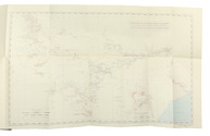
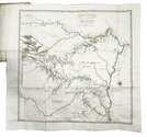
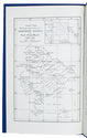
Map of Alios Musil's journeys

PEUCKER, Karl. 
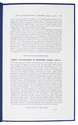
Musils explorations in Northern Arabia, 1908-9.
[London, W. Clowes, May 1910]. With a full-page black and white lithographed map (19x12.5 cm). 4to. With a full-page lithographed black and white map. Modern blue wrappers. 579-581 pp. Full description
€ 300
Order Inquire Terms of sale

19th-century Java described

PFYFFER ZU NEUECK, Joseph Jacob Xaver. Esquisses de l'ile de Java et de ses divers habitants, recueillies pendant un séjour de huit années fait dans cette île; ... traduit de l'Allemand par Girodz du Villard, revu et mis en ordre par G. Guénot Lecointe.
Brussels, P.J. Voglet for Société Belge de Librairie, Hauman, Cattoir and company, 1837. 12mo. Modern grained brown half calf preserving the original lithographed wrappers, partly uncut. [4], III, [1 blank], XV, [1 blank], 239, [1 blank] pp. Full description
€ 2,950
Order Inquire Terms of sale

The first European crossing the Rub' al-Khali (Empty Quarter) of Arabia from east to the west

PHILBY, Harry St. John Bridger and Alfred Felix Landon BEESTON. Sheba's daughters beign a record of travel in southern Arabia. With an appendix on the rock inscriptions by A.F.L. Beeston.
London, Methuen & Co., [1939]. 4to. With photographic frontispiece, 46 photographic plates (1 of which double-page), 1 folding map of southern Arabia, and several photographic illustrations in the text. Contemporary light yellow cloth with giltstamped title and ornament to the spine. XIX, [1 blank], 485, [1] pp. Full description
€ 350
Order Inquire Terms of sale

Pendant of a drawing in the Amsterdam city archives, together with two engravings after the drawing

[AMSTERDAM]. PHILIPS, Caspar Jacobsz. Afbeelding van de Oostzijde der Muijder Poort te Amsterdam, na dat dezelve tussen den 29 en 30 Januarij 1769 bij na 16 voeten diep in de grond gezakt was.
[Netherlands], 1772. (23 x 29 cm). Original pen drawing.
With:
(2) KEUN, Hendrik. Afbeelding van de Muyderpoort te Amsterdam, zo als die zig vertoonde, na dat dezelve tussen den 29 en 30 Jannuary 1769 by de 16 voeten in de grond gezakt was.
Amsterdam, F.W. Greebe, [1769]. (22 x 28.7 cm)
(3) KEUN, Hendrik. Afbeelding van de Muyderpoort te Amsterdam, zoo als die ingezakt synde, van buiten af te zien zig vertoond.
Amsterdam, F.W. Greebe, [1769]. (21.7 x 28.2 cm.
Two engraved views with captions below the image, both signed "H. Keun Fecit" in the plate. Full description
€ 2,500
Order Inquire Terms of sale

Interesting and intimate photograph album showing buildings, views, people and life in Calcutta in the 1870s

[PHOTOGRAPHY - INDIA]. [Manuscript title on the front paste-down:] Views of Calcutta.
Calcutta, [ca. 1874/79]. Oblong 8vo. With 33 mounted sepia albumen prints (ca. 15/15.5 x 10.5/11 cm), all captioned. Manuscript title and captions of the pictures in English, written in brown ink in a neat 19th-century cursive hand. Contemporary gold-tooled half red morocco, brown cloth sides. [2 blank], [25], [1 blank], [8], [2 blank] pp. Full description
€ 6,500
Order Inquire Terms of sale

The land, indigenous peoples and colonists in Nova Scotia, by a French official spying for England

[PICHON, Thomas]. Lettres et memoires pour servir à l'histoire naturelle, civile et politique de Cap Breton, ...
The Hague, Pierre Gosse; London, Jean Nourse [printed in England], 1760. 12mo. Half brown morocco (ca. 1885?), by Frank J. Pfister in New York, gold-tooled spine, round gold stamp of Henry Gurdon Marquand on the front. XVI, 327, [1 blank] pp. Full description
€ 1,250
Order Inquire Terms of sale

One of the earliest sources on the Congo and central Africa, complete with all plates and maps

PIGAFETTA, Filippo and Duarte LOPEZ. Relatione del reame di Congo et delle circonvicine contrade tratta dalli scritti & ragionamenti di Odoardo Lopez.
Rome, Bartolomeo Grassi, [1591]. 4to. With an integral engraved architectural title-page (with the coat of arms of the dedicatee Antonio Migliore, Bishop of San Marco), large folding engraved general map of Africa (64×44 cm), large folding engraved map of the Congo (43.5×51.5 cm) and 8 numbered folding engraved plates of plants, animals and inhabitants of the country, by Natalis Bonifazio. Contemporary limp sheepskin parchment. [8], 82, [1], [1 blank] pp. Full description
€ 60,000
Order Inquire Terms of sale

Exploring New Mexico and Louisiana and searching for the source of the Mississippi,
while unknowingly supporting plans for empire in the Southwest

PIKE, Zebulon Montgomery. Reize naar Nieuw-Mexico en de binnenlanden van Louisiana, voorgegaan door eenen togt naar de bronnen der Mississippi.
Amsterdam, Cornelis Timmer (colophon: printed by A. Breeman & Co.), 1812. 2 volumes. 8vo. With 3 engraved folding maps: the first two showing the interior of Louisiana and the third the Mississippi River. Contemporary half calf, gold-tooled spine. VIII, 327, [1]; [4], 374 pp. Full description
€ 4,950
Order Inquire Terms of sale
652 books found / Show all