Categories
Shopping cart (0 items € 0)
Advanced search

Cartography & Exploration

North-West Passage not through Hudson Bay

ELLIS, Henry. Reize naar de baai van Hudson, ter ontdekkinge van eenen Noord-wester doortogt, gedaan in de jaaren 1746. en 1747.
Leiden, Elie Luzac jun., 1750. 8vo. With large folding engraved map (18 x 44.5 cm), and 9 engraved plates, mostly folding by N. van Frankendaal, with captions in French and Dutch. Contemporary red half roan. XXXII, 440 pp. Full description
€ 2,950
Order Inquire Terms of sale

Afghanistan and its dependencies in Persia, Tartary and India, with 14 hand-coloured plates, in original wrappers

ELPHINSTONE, Mountstuart. Tableau du royaume de Caboul, et de ses dépendances, dans la Perse, la Tartarie et l'Inde, offrant les moeurs, usages et costumes de cet empire, ... traduit et abrégé de l'anglais, par M. Breton.
Paris, Nepveu, 1817. 3 volumes. 18mo. With 14 engraved plates depicting various costumes, lords on horseback, etc., all beautifully coloured by hand. Original publisher's printed wrappers, each volume with wood engraved illustrations on front, back and spine. Preserved in a modern gold-tooled green morocco box. XLIV, 189 [3]; [4], 222, [2]; [4], 223 [1] pp. Full description
€ 4,950
Order Inquire Terms of sale

Pocket atlas of the Low Countries with the world and the continents,
coloured by a contemporary hand

ELWE, Jan Barend. Compleete zak-atlas, van de zeventien Nederlandsche provinciën, begreepen in XXXI ... in 't koper gebragte kaarten.
Amsterdam, Jan Barend Elwe and Dirk Meland Langeveld, 1786. 8vo. With double-page engraved title-page, 29 folding engraved maps and 2 folding engraved tables, all coloured by a contemporary hand. Contemporary half calf, rebacked with the original gold-tooled backstrip. 243, [1] pp. text Full description
€ 2,950
Order Inquire Terms of sale

Pocket atlas of the Low Countries with the world & the continents

ELWE, Jan Barend. Compleete zak-atlas, van de zeventien Nederlandsche Provinciën.
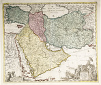
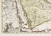
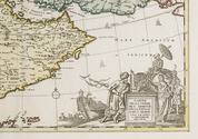
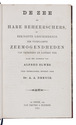
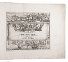
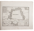
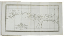
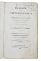
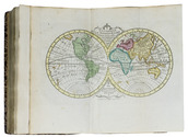
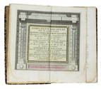
Amsterdam, J.B. Elwe & D.M. Langeveld, 1786. 8vo. With a double-page engraved title, 29 numbered folding engraved maps (the first 5 signed by A. van Krevelt) and 2 folding engraved tables, all coloured by a contemporary hand. Contemporary half calf, gold-tooled spine. 239, [1] pp. Full description
€ 2,950
Order Inquire Terms of sale

History of seafaring

ELWES, Alfred and A.A. DEENIK (translator). De zee en hare beheerschers, of beknopte geschiedenis der voornaamste zeemogendheden uit vroegeren en lateren tijd.
Sneek, Van Druten and Bleeker, 1861. 8vo. Contemporary red half sheepskin. XXV, 368 pp. Full description
€ 500
Order Inquire Terms of sale

Beijing in the late 19th century, illustrated with numerous photographs

FAVIER, Alphonse. Péking histoire et description.
Peking, Imprimerie des Lazaristes au Pe-Tang, 1897. 35.5 x 25.5 cm. 2 volumes bound as 1 (continuous page numbers). With a frontispiece to each part, 51 plates with photolithographs and collotypes, 1 tinted map and 660 wood engraved illustrations in text. Modern half cloth, with the original wrappers bound in. XII [4], 336, [4], 337-“562” [=552], [2] pp. Full description
€ 6,500
Order Inquire Terms of sale

The division of Oregon Country between Britain and the United States of America

FÉDIX, P.A. L'Orégon et les côtes de l'Océan Pacifique du Nord, aperçu géographique, statistique et politique, avec une carte du pays d'après les documens les plus récens.
Paris, Librairie de Amyot (printed by Éd. Proux et Cie), 1846. 8vo. With a large folding map (40 x 52.5 cm) depicting what the United States called Oregon Country, dated 1846 and partly coloured in outline. Modern maroon half morocco. 258 pp. Full description
€ 9,500
Order Inquire Terms of sale

First printing of a rare 18th-century map of Portuguese Angola

FEO CARDOZO DE CASTELLOBRANCO E TORRES, João Carlos. Memorias contendo a biographia do vice almirante Luiz da Motta Feo e Torres. A historia dos governadores e capitaens generaes de Angola, desde 1575 até 1825, e a descripção geographica e politica dos reinos de Angola e de Benguella.
Paris, Fantin, 1825. 3 parts in 1 volume. 4to. With one large folding map at the start of the first volume, showing the coast of Angola, and a small vignette on the title page. Contemporary gold-tooled tree-marbled calf. [14], 375, [6] pp. Full description
€ 2,950
Order Inquire Terms of sale

Europe fortified: the fortifications of Marolois, Stevin and Vauban, beautifully mapped,
together with an atlas of the coasts of France, also with fortifications

FER, Nicolas de. Les forces de l' Europe, ou description des principales villes; avec leurs fortifications. . . .
Paris, "chez l'auteur" [=Nicolas de Fer, a false imprint], 1695-1696 [printed in Amsterdam, for Pieter Mortier, 1695-ca. 1702]. 10 parts in 1 volume. With 234 beautifully engraved plates (a few folding) with 366 maps and views of fortified cities.
With: (2) FER, Nicolas de. Costes de France, sur l' ocean & sur la Mer Mediterranée &c. avec leurs fortifications. . . .
Paris, "Nicolas de Fer" [a false imprint], 1695. [printed in Amsterdam, for Pieter Mortier]. With engraved title-page and 40 engraved plates (including 2 folding). 2 works in 12 parts or volumes, bound as 1 volume. Oblong 1mo (30×37 cm). Contemporary tanned sheepskin, gold-tooled spine. Full description
€ 17,500
Order Inquire Terms of sale
650 books found / Show all