
Exceptional Portolan chart, likely made by famed cartographer and chart maker, Luis Texeira
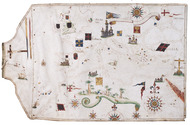
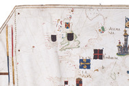
[PORTOLAN CHART - Luis TEXEIRA].
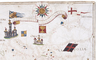
[Portolan chart of the Mediterranean basin].
[Iberian peninsula, second half of the 16th century, before 1574?]. 96 x 61 cm. Manuscript nautical chart on a single sheet of vellum, centred on the Mediterranean basin. Full description
€ 325,000
[Iberian peninsula, second half of the 16th century, before 1574?]. 96 x 61 cm. Manuscript nautical chart on a single sheet of vellum, centred on the Mediterranean basin. Full description