Categories
Shopping cart (0 items € 0)
Advanced search

Asia / India & Sri Lanka

A standard navigational directory for the Indian Archipelago

FINDLAY, Alexander George. A directory for the navigation of the Indian archipelago and the coast of China, from the Straits of Malacca and Sunda, and the passages east of Java, to Canton, Shanghai, the Yellow Sea, and Korea. With the descriptions of the winds, monsoons, and currents, and general instructions for the various channels, harbours, etc. Third edition.
London, Richard Holmes Laurie, 1889. Royal 8vo. With 11 folding maps and charts. Original publishers blindstamped cloth, lettered in gold. XLVIII, IV, 1478; [2], 8 pp. Full description
€ 2,500
Order Inquire Terms of sale

Beautifully illustrated account of the first Earl of Munster's journey overland from India via Egypt to England

FITZCLARENCE, George Augustus Frederick. Journal of a route across India, through Egypt, to England in a latter end of the year 1817, and the beginning of 1818.
London, printed by Thomas Davidson for John Murray, 1819. Large 4to. With 12 plates, including one of "Pettah the Citadel etc." as a frontispiece and 7 maps and plans, including 1 folding, with 3 additional explanatory letterpress leaves for maps 2-4 (Jubbulpoor [Jabalpur], Nagpoor [Nagpur], Meinpoor [Mahidpur]). 9 of 12 plates are hand-coloured aquatints and 5 of 7 maps and plans are coloured in outline. Contemporary gold-tooled calf with a blind-tooled decorative border. XXIV, [1], [1 blank], [1], [1 blank], 502 pp. Full description
€ 5,000
Order Inquire Terms of sale

One of the first Sanskrit works published in Germany

FRANK, Othmar Chrestomathia Sanskrita, quam ex codicibus manuscriptis, adhuc ineditis, Londini exscripsit, atque in usum Tironum versione, expositione, tabulis grammaticis etc. illustratam edidit ...
Munich, typographice ac lithographice opera et sumtibus propriis, 1820-1821. 2 parts in 1 volume. Large 4to (22 x 25,5 cm). With 6 lithographed plates (4 folding). Original temporary grey boards as issued. XII, 194, [2]; [4], 147, [3] pp. Full description
€ 2,500
Order Inquire Terms of sale

The first English edition of a famous biography of the fourth Portuguese viceroy of India

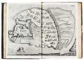
FREIRE DE ANDRADE, Jacinto and Peter WYCHE (translator). The life of Dom John de Castro, the fourth Vice-Roy of India. Wherein are seen the Portuguese's voyages to the East-Indies; their discoveries and conquests there; the form of government, commerce, and discipline of warr[!] in the East, and the topography of all India and China. Containing also a particular relation of the most famous siege of Dio, with a map to illustrate it.
London, Henry Herringman, 1664. Folio. With a full-page engraved portrait of D. João de Castro, the fourth viceroy of India as a frontispiece, signed "W. Faithorne sculp.", one full-page engraved illustration of the shrine of St. Thomas in Meliapor - including its inscriptions in Sanskrit - which already existed at the time of the Portuguese arrival in India, and one double page engraved map (view) of Diu and its fortress. Contemporary blind-tooled calf. [1], [1 blank], [18], 272, [19], [1 blank] pp. Full description
€ 16,500
Order Inquire Terms of sale

French commerce via Egypt and the Red Sea before the opening of the Suez Canal

FROMENT, Dominique. Du commerce des Europeens avec les Indes, par la Mer Rouge et par l'Egypte.
Paris, Dugour et Durant, an VII [= 1799]. 8vo. With a very large, folding map showing the fastest route from France to India (via the Mediterranean, Egypt, the Red Sea and the Indian Ocean), 7 folding tables, and a woodcut illustration at the head of the first chapter. Contemporary dark blue paper wrappers, protected by a semi-opaque coated paper dust jacket. [2], XIV, 211, [1 blank] pp. Full description
€ 7,500
Order Inquire Terms of sale

The natural history, politics and medicine of India and Persia, with a section on Muscat

FRYER (FREYER), John. Negenjaarige reyse door Oostindien en Persien, ... Begonnen met den jaare 1672 en geeyndigt met den jaare 1681.
The Hague, Abraham de Hondt, Jacobus van Ellinkhuysen and Meyndert Uytwerf, 1700. 4to. With engraved frontispiece, engraved author's portrait, 3 folding engraved maps, 7 folding engraved views and other plates, and several woodcut illustrations in text. Contemporary vellum. [8], 566, [26] pp. Full description
€ 3,750
Order Inquire Terms of sale

The most accurate map of India and the Gulf region to its time

[GASTALDI, Giacomo]. Seconda tavola.
[Venice], Ferrando Bertelli, 1565 [printed ca. 1570]. Engraved map of the Indian Ocean, Indian subcontinent and most of the Gulf region (28 x 39 cm; margins extended to 50 x 66.5 cm), at a scale of about 1:13,500,000 with north at the foot, with 3 sea monsters, a spouting whale and 3 ships in the ocean; and on the land elephants, lions and 2 people on horseback carrying spears. Although printed from a single copper plate, the present map image is divided into two parts, with a 7 mm gap between the right and left halves, so that nothing would be lost if the map were bound as a double-page plate. Full description
€ 18,000
Order Inquire Terms of sale
208 books found / Show all