Categories
Shopping cart (0 items € 0)
Advanced search

Africa / Cartography & Exploration

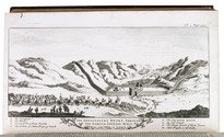
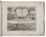
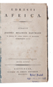
18th-century colonial history of Mauritius, with an eye-witness account of the battle of Madras

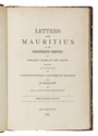
GRANT, Charles, vicomte de VAUX and John Pope HENNESSY. Letters from Mauritius in the eighteenth century by Grant, Baron de Vaux including an account of Labourdonnais' capture of Madras.
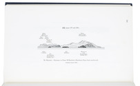
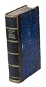
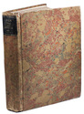
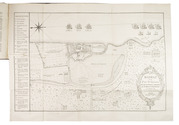
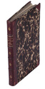
Mauritius, printed for private circulation, 1886. 8vo. With a large, folding engraved map (43x59 cm). Contemporary half gold- and blind-tooled red calf, decorated (pseudo-marbled) paper sides. With the author and title lettered in gold on the spine. [2], X, 192, VI pp. Full description
€ 3,950
Order Inquire Terms of sale

The British navy's pilot guide for crossing the South Indian Ocean

[GREAT BRITAIN, HYDROGRAPHIC DEPARTMENT]. South Indian Ocean pilot. Madagascar, Îles Comores, Île de la Réunion, Mauritius, Seychelles Group, Chagos Archipelago, and other islands lying westward of Longitude 80° East. Eighth edition.
Taunton, published by the hydrographer of the navy, 1971. With supplement no. 5 (1977). 8vo. With 2 small maps, 8 coastal profiles, 9 diagrams and 11 climatic tables in the book and also 1 view of the coast of Marie Louise Islet (1975) in the supplement.Contemporary blue cloth with printed title in yellow. XI, [1 blank], 333, [1]; 40 pp. Full description
€ 600
Order Inquire Terms of sale

The British navy's pilot guide for crossing the South Indian Ocean

[GREAT BRITAIN - HYDROGRAPHIC DEPARTMENT]. South Indian Ocean Pilot. Madagascar, Îles Comores, Île de la Réunion, Mauritius, Seychelles Group, Chagos Archipelago, and other islands lying westward of Longitude 80° East. Eight edition.
Taunton, published by the hydrographer of the navy, 1971. With supplement no. 6 (1979). 8vo. With 2 small maps, 8 coastal profiles, 9 diagrams and 11 climatic tables in the book and also 1 view of the coast of Marie Louise Islet (1975) in the supplement. Contemporary blue cloth with printed title in yellow. XI, [1 blank], 333, [1]; 47 pp. Full description
€ 600
Order Inquire Terms of sale

Over forty plates of East Africa based on daguerrotypes

GULLAIN, Charles. Documents sur l'histoire, la geographie et le commerce de l'Afrique orientale.
Paris, Arthus Bertrand, [1856-1857]. 3 text volumes and 1 atlas volume. Text volumes: 8vo; atlas volume: folio. With 55 tinted plates. Contemporary leather-backed marbled boards. XXXI, [1], 628; XXIII, [1], 556; [4], 527, [1 blank] pp. Atlas volume: [4] pp. and 55 plates. Full description
€ 35,000
Order Inquire Terms of sale

One of the best 18th-century collections of travels and descriptions of various parts of the world,
with the fine Bowen maps

HARRIS, John. Navigantium atque itinerantium bibliotheca. Or, a complete collection of voyages and travels. Consisting of above six hundred of the most authentic writers, beginning with Hackluit, Purchass, &c. in English Ramusio, Alamandini, Carreri, &c. in Italian ... Together with such other histories, voyages, travels, of discoveries, as are in general esteem; ... containing whatever has been observed worthy of notice in Europe, Asia, Africa, and America ...
London, Printed for T. Woodward, A. Ward, S. Bird (and 12 others), 1744-48. 2 volumes. Large folio (41 x 25 cm). With the title-pages printed in red and black, 22 maps (16 folding, 6 full-page), 2 full-page plans, 37 full-page plates, and numerous decorated woodcut initials and head- and tail pieces. Contemporary gold-tooled mottled brown calf, richly gold-tooled spines with red morocco title labels lettered in gold, gold-tooled board edges, red edges. [12], XVI, [4], 984; [10], 1056, [10] pp. Full description
€ 20,000
Order Inquire Terms of sale

Fine work illustrating the cities, ports, and factories of the Dutch East India Company in Asia and Africa

HEYDT, Johann Wolffgang. Allerneuester Geographisch und Topographischer Schau-Platz, von Africa und Ost-Indien.
Nuremberg, C. Tetschner, 1744. Oblong folio (31 x 36.5 cm). With 115 numbered engraved maps and plates, an engraved frontispiece, and an engraved title page. Contemporary vellum, with the author and title lettered in gold on the spine, red edges. [24], 345, [4] pp. Full description
€ 17,500
Order Inquire Terms of sale

Massive navigational directory, with sections on the Arabian Sea, the Red Sea and the Gulf

HORSBURGH, James, Gerrit KUIJPER and D. BOES LUTJENS. Zeemans-gids, naar, in en uit Oost-Indiën, China, Japan, Australiën, de Kaap de Goede Hoop, Braziliën en tusschenliggende havens, volgens de vierde Engelsche uitgave van James Horsburgh, ...
Amsterdam, C.F. Stemler, (back of half-title: printed in Haarlem by H. Bakels), 1841. 4to. Contemporary half calf, spine lettered in gold, marbled sides. I-XII, [2], XIII-XXIV, XXVIII, 1376 pp. Full description
€ 3,750
Order Inquire Terms of sale

First substantial English translation of Ibn Batuta's travels through the Islamic world and beyond

IBN BATUTA and Samuel LEE (editor). The travels of Ibn Batuta; translated from the abridged Arabic manuscript copies, preserved in the public library of Cambridge. With notes, illustrative of the history, geography, botany, antiquities, &c. occurring throughout the work.
London, printed for the Oriental Translation Committee (colophon: by J.L. Cox). Large 4to (32 x 26). With various passages including the original Arabic text. Later half calf. "XVIII" [=XX], [2], 243, [1] pp. Full description
€ 17,500
Order Inquire Terms of sale

Historical narrative of a voyage to India and Persia written by a surgeon of the British Royal Navy

IVES, Edward. Reize naar Oost-Indië en Persië, en de daar omliggende landen. Ondernomen langs een' ongewoonen weg.
Amsterdam, De Compagnie, 1779. 2 volumes bound as 1. 4to. With 2 engraved title-pages, 2 folding engraved maps, one of India (44 x 51 cm), the other tracking Ives's journey from Basra to Latakia (ca. 42 x 56 cm), and 9 engraved plates (including 1 large folding). Early 20th-century boards. [16], 324; [1], [1 blank], [1], [1 blank], 379, [1] pp. Full description
€ 2,950
Order Inquire Terms of sale
87 books found / Show all
Recently viewed