Home
Shopping cart (0 items € 0)
Advanced search

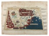
First printed record of Abu Dhabi and Dubai: the first Latin edition

DE BRY, Theodor; Johann Israel DE BRY and Joris VAN SPILBERGEN. Indiae Orientalis pars septima [...].Including: Icones, hoc est verae variorum populorum et regum, ceremoniarum item, superstitiosorum rituum et rerum aliarum, ...
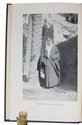
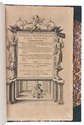
Frankfurt, Wolfgang Richter, 1606. Folio (32.5 x 20 cm). With the letterpress title in an engraved architectural border, a separate letterpress title-page for the Icones, an engraved coat of arms on the dedication leaf, 20 engravings in text and 2 double-page engraved plates. 20th-century green half morocco. [4], 126, [2 blank] pp.; 26 ll. Full description
€ 28,000
Order Inquire Terms of sale

British military terrain map of the Persian Gulf, published in Calcutta

HUNTER, Frederic Fraser (editor); Sir Sidney Gerald BURRARD (director). Southern Asia series - Southern Persia sheet - Persia, Arabia and Turkey in Asia
[Dehradun, Survey of India Office], sold at the Map Record and Issue Office, Calcutta, 1912. 61.5 x 88 cm. Large photozincographed (heliozincographed) folding map on a scale of 1:2,000,000 in black, blue and red, with relief shown by contours, hachures and gradient tints. Folded. Full description
€ 15,000
Order Inquire Terms of sale

Concise handbook for Western travellers visiting the Gulf States

KILNER, Peter and Jonathan WALLACE (editors). A guide for businessmen and visitors. The Gulf handbook 1978.
Bath and London, Trade and Travel Publications and MEED, 1978. 17.5 x 12 cm. With 8 sections of a map (2 full-page and 3 double-page) in colour of showing several parts of the Arabian peninsula, 8 full-page black-and-white photographic portraits of the Heads of State of the different Gulf States, 21 black-and-white maps and plans of these states and their largest cities, and numerous advertisements (partially in colour) throughout. Original illustrative printed boards, showing an Arab man with a gun in front of a large satellite dish and an advert for Arab Wings showing a plane in the sky on the back. XII, 576 pp. Full description
€ 350
Order Inquire Terms of sale

Warmly inscribed by the author

PALGRAVE, William Gifford. Personal narrative of a year's journey through Central and Eastern Arabia (1862-63).
London and New York, Macmillan and Co., 1871. 8vo (ca. 13 x 19 cm). With a linen-backed folding map and 3 extending plans. Contemporary half morocco with maroon cloth over boards, gilt, front board stamped with the owner's initials "G.W.T.", marbled endpapers. [2], VI, [4], 421, [1] pp. Full description
€ 2,500
Order Inquire Terms of sale

One of the earliest maps of Arabia, with unique contemporary illumination

[MAP - ARABIAN PENINSULA]. PTOLEMAEUS, Claudius. [Jacobus ANGELUS, trans.; Nicolaus GERMANUS, ed.]. Sexta Asie Tabula.
Ulm, Lienhart Holle, 1482. Oblong 1mo (whole sheet: 41.5 by 57 cm). With a double-page woodcut map. Finely coloured by a contemporary hand, with near-contemporary manuscript vignette illustrations of an Ababeel bird, Makkah (Mecca) and the Kaaba in pen and wash highlighted in gold. Full description
€ 150,000
Order Inquire Terms of sale
7 books found